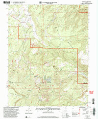
2002 Map of Grover
USGS Topo · Published 2005About this map
Grover and the small cluster at Corral sit at the northern edge of this high-altitude landscape, where the Highway 12 All American Road winds through the transition between high plateaus and canyon country. The map documents a complex intersection of public lands, including portions of Dixie National Forest, Fishlake National Forest, and the western reaches of Capitol Reef National Park. The terrain is deeply incised by drainages such as Carcass Creek and Sulphur Creek, leading into features like Cuts Canyon and Capitol Wash. To the south, the massive uplift of Boulder Mountain dominates the horizon, punctuated by Chokecherry Point and high alpine clearings like Rock Creek Meadow. Local industry and land use are evident through several Mine Shaft labels and a Prospect near Miners Hollow, while the Singletree Trail and a Scenic Overlook point to the area's role in recreation and conservation within the Loa Teasdale Ranger District.
Find a feature on this map
55 named features on this map. Tap any name to fly to it.
Don’t see what you’re looking for? This feature index may not catch every label — zoom into the map to look around manually.
Map Details
Editions of this 2002 Grover Map
This is the sole edition of this map. No revisions or reprints were ever made.
Other maps of this area

1885 · Fish Lake
USGS Topo · 1:250,000

1896 · Fish Lake
USGS Topo · 1:250,000

1952 · Notom 3 SW
USGS Topo · 1:24,000

1952 · Notom 3 NW
USGS Topo · 1:24,000

1952 · Notom 2 SE
USGS Topo · 1:24,000

1952 · Notom 2 SW
USGS Topo · 1:24,000

1952 · Notom 4 NW
USGS Topo · 1:24,000

1952 · Notom 4 SW
USGS Topo · 1:24,000

1952 · Notom 3 SE
USGS Topo · 1:24,000

1952 · Notom 3 NE
USGS Topo · 1:24,000