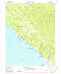
1977 Map of Gualala
USGS Topo · Published 1978About this map
The Gualala River marks the southern border of this coastal survey, where the river meets the Pacific Ocean at the boundary of Mendocino Co and Sonoma Co. The settlement of Gualala serves as a hub for the local timber and ranching economy, with a Lumber Mill situated near the riverbanks and a complex network of coastal landings such as Bourns Landing, Collins Landing, and Steens Landing reflecting the region's maritime history. Inland, the terrain rises sharply toward Signal Ridge and Gualala Mtn, deeply etched by numerous gulches like Robinson Gulch and China Gulch. Small family and community landmarks such as the Bourn Cem, Seaside Sch, and Wildwood Ranch are scattered throughout the hills, providing valuable data points for genealogists tracing the early residents of this isolated stretch of the Redwood Coast.
Find a feature on this map
57 named features on this map. Tap any name to fly to it.
Don’t see what you’re looking for? This feature index may not catch every label — zoom into the map to look around manually.
Map Details
Editions of this 1977 Gualala Map
This is the sole edition of this map. No revisions or reprints were ever made.
Other maps of this area

1921 · Plantation
USGS Topo · 1:62,500

1943 · Point Arena
USGS Topo · 1:62,500

1943 · Stewarts Point
USGS Topo · 1:24,000

1943 · Ornbaun
USGS Topo · 1:62,500

1944 · Stewarts Point
USGS Topo · 1:31,680

1944 · Ornbaun
USGS Topo · 1:62,500

1947 · Santa Rosa
USGS Topo · 1:250,000

1949 · Santa Rosa
USGS Topo · 1:250,000

1958 · Santa Rosa
USGS Topo · 1:250,000

1960 · Saunders Reef
USGS Topo · 1:24,000