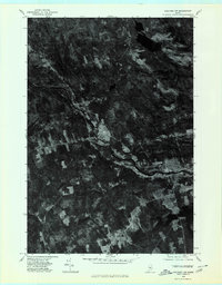
1975 Map of Guilford NW
USGS Topo · Published 1980About this map
The Piscataquis River and its confluence with Kingsbury Stream anchor this orthophotoquad, revealing the mid-1970s development patterns of several Maine settlements. The imagery captures the physical relationship between the river and the towns of Guilford, Abbot Village, and Upper Abbot, where cleared agricultural fields and industrial sites contrast sharply against the dense forest of Moosehorn. This aerial perspective shows the distinct cluster of the North Guilford area near the northern waters and the southern reach of Parkman near Harlow Pond. The transition from riverbank industry to timberland is clearly visible, providing a detailed record of the landscape before significant modern changes. Researchers can trace historical property lines, road networks, and the water-driven development that historically defined this part of Piscataquis County.
Find a feature on this map
10 named features on this map. Tap any name to fly to it.
Don’t see what you’re looking for? This feature index may not catch every label — zoom into the map to look around manually.
Map Details
Editions of this 1975 Guilford NW Map
This is the sole edition of this map. No revisions or reprints were ever made.
Other maps of this area

1933 · Guilford
USGS Topo · 1:62,500

1937 · Guilford
USGS Topo · 1:62,500

1948 · Kingsbury
USGS Topo · 1:62,500

1950 · Kingsbury
USGS Topo · 1:62,500

1950 · Sebec Lake
USGS Topo · 1:62,500

1951 · Greenville
USGS Topo · 1:62,500

1954 · Millinocket
USGS Topo · 1:250,000

1958 · Millinocket
USGS Topo · 1:250,000

1960 · Millinocket
USGS Topo · 1:250,000

1975 · Kingsbury NE
USGS Topo · 1:24,000