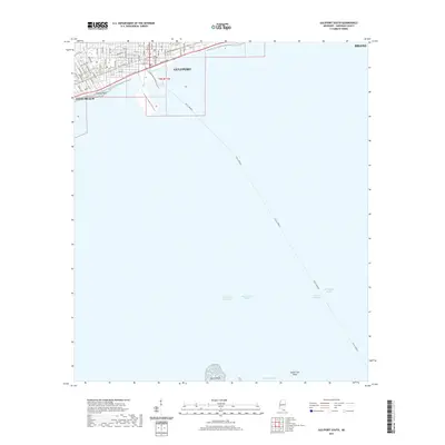
2021 Map of Gulfport South
USGS Topo · Published 2021About this map
Gulfport and the adjacent shoreline of Long Beach anchor the northern edge of this coastal survey, where the urban grid meets the Mississippi Sound. The map focuses heavily on the maritime infrastructure of the Mississippi coast, highlighting the deep-water Gulfport Channel and the transit lines of the Ferry (Water) crossing the sound. While the mainland portion shows established streets like W Beach Blvd and Old Pass Rd, the majority of the sheet is dedicated to the nautical geography of the Intracoastal Waterway and various hazards and harbors. To the south, isolated features such as North Point, Spade Fish Shoal, and Raccoon Swash provide crucial landmarks for navigating the shallow waters near Man of War Harbor. This document effectively illustrates the spatial relationship between the developed city front at Gaston Point and the vast aquatic territory that drives the regional economy.
Find a feature on this map
63 named features on this map. Tap any name to fly to it.
Don’t see what you’re looking for? This feature index may not catch every label — zoom into the map to look around manually.
Map Details
Editions of this 2021 Gulfport South Map
This is the sole edition of this map. No revisions or reprints were ever made.
Other maps of this area

1893 · Cat Island
USGS Topo · 1:62,500

1946 · Isle Au Pitre
USGS Topo · 1:31,680

1950 · Ship Island
USGS Topo · 1:24,000

1951 · Cat Island
USGS Topo · 1:24,000

1953 · Mobile
USGS Topo · 1:250,000

1954 · Isle Au Pitre
USGS Topo · 1:31,680

1954 · Gulfport North
USGS Topo · 1:24,000

1954 · Gulfport South
USGS Topo · 1:24,000

1954 · Biloxi
USGS Topo · 1:24,000

1954 · Biloxi
USGS Topo · 1:62,500