1941 Map of Gunpowder
USGS Topo · Published 1941About this map
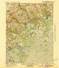
Gunpowder Falls and Little Gunpowder Falls carve through the landscape of northeastern Maryland, converging before they meet the Chesapeake Bay. Prepared under the direction of the Corps of Engineers, this survey captures the rural and maritime character of the region just before wartime industrial shifts accelerated. The landscape is defined by its deep estuaries and points, such as Maxwell Point and Rickett Point, which frame the intricate shoreline of the Bird River and Bush River. Inland, the settlement pattern follows early colonial footprints and industrial sites like Harford Furnace and the Osbornes Ruins. Transportation is anchored by the Baltimore and Ohio Railroad and the P.R.R. System, which bisect small crossroads like Jerusalem and Abingdon, while the military presence at Graces Quarters indicates the strategic importance of this coastal corridor.
Find a feature on this map
115 named features on this map. Tap any name to fly to it.
Don’t see what you’re looking for? This feature index may not catch every label — zoom into the map to look around manually.
Map Details
Editions of this 1941 Gunpowder Map
This is the sole edition of this map. No revisions or reprints were ever made.
Other maps of this area

1893 · North Point
USGS Topo · 1:62,500

1893 · Gunpowder
USGS Topo · 1:62,500

1894 · Baltimore
USGS Topo · 1:62,500

1894 · Relay
USGS Topo · 1:62,500

1898 · Tolchester
USGS Topo · 1:125,000

1899 · Baltimore
USGS Topo · 1:62,500

1900 · Havre De Grace
USGS Topo · 1:62,500

1900 · Betterton
USGS Topo · 1:62,500

1900 · Parkton
USGS Topo · 1:62,500

1901 · Belair
USGS Topo · 1:62,500