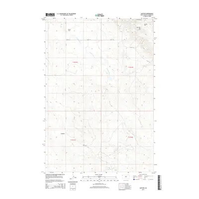
2015 Map of Gustave
USGS Topo · Published 2015About this map
Gustave serves as the quiet focal point of this Harding County landscape, where the high plains of South Dakota meet the distinct elevations of the West Short Pine Hills. The topography is defined by the drainages of the S Fork Moreau River, Forty-eight Mile Cr, and Bickerdike Cr, which carve through the open range. Local history is anchored at the Gustave Cem, while the rugged northern heights are marked by Harding Peak and Sawmill Gulch. This modern survey by the U.S. Geological Survey illustrates a ranching-and-river landscape where traditional land divisions like t16n r1e and roads like Collins Rd still dictate the rhythm of the terrain near Sheep Draw and Split Rock Spring.
Find a feature on this map
16 named features on this map. Tap any name to fly to it.
Don’t see what you’re looking for? This feature index may not catch every label — zoom into the map to look around manually.
Map Details
Editions of this 2015 Gustave Map
This is the sole edition of this map. No revisions or reprints were ever made.
Other maps of this area

1935 · Harding
USGS Topo · 1:125,000

1954 · Lemmon
USGS Topo · 1:250,000

1954 · Ekalaka
USGS Topo · 1:250,000

1956 · Ekalaka
USGS Topo · 1:250,000

1957 · Lemmon
USGS Topo · 1:250,000

1958 · Ekalaka
USGS Topo · 1:250,000

1965 · Ekalaka
USGS Topo · 1:250,000

1973 · Hells Canyon
USGS Topo · 1:24,000
1977 · Harding
USGS Topo · 1:24,000
1978 · J K Butte
USGS Topo · 1:24,000