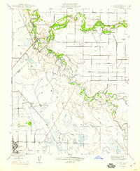
1947 Map of Gustine
USGS Topo · Published 1947About this map
The confluence of the Merced River and the San Joaquin River dominates this Central Valley landscape, which shows the transition from riparian wetlands to organized agriculture in the late 1940s. The town of Gustine is the primary hub of activity, anchored by the So Pacific railroad line and a dense grid of local streets. The surrounding countryside reveals a mix of recreational and working land, including the Newman Gun Club and several named agricultural estates like the Stevinson Home-Ranch and Hartman Ranch.
Find a feature on this map
24 named features on this map. Tap any name to fly to it.
Don’t see what you’re looking for? This feature index may not catch every label — zoom into the map to look around manually.
Map Details
Editions of this 1947 Gustine Map
This is the sole edition of this map. No revisions or reprints were ever made.
Other maps of this area

1916 · Mitchell School
USGS Topo · 1:31,680

1916 · Crows Landing
USGS Topo · 1:31,680

1917 · Turlock
USGS Topo · 1:31,680

1917 · Newman
USGS Topo · 1:31,680

1918 · Stevinson
USGS Topo · 1:31,680

1918 · Gustine
USGS Topo · 1:31,680

1919 · Orestimba
USGS Topo · 1:62,500

1919 · San Luis Ranch
USGS Topo · 1:31,680

1919 · Ingomar
USGS Topo · 1:31,680

1920 · Pacheco Pass
USGS Topo · 1:62,500