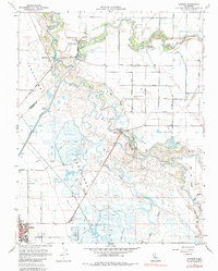
1960 Map of Gustine
USGS Topo · Published 1982About this map
Gustine and the surrounding agricultural landscape of western Merced County are defined by a complex network of waterways and early 20th-century transportation routes. The confluence of the San Joaquin River and the Merced River dominates the northern portion of the map, supporting riparian recreation at George J Hatfield State Park and Fremont Ford State Park. This region is a study in reclaimed wetlands, where extensive duck ponds and sloughs like Mud Slough and Salt Slough sit alongside irrigation infrastructure including the San Luis Canal and Newman Wasteway. The rural economy of the 1960s is evidenced by the prominent Stevinson Home Ranch and local leisure sites like the Newman Gun Club. Transportation and industry center on the southern part of the quadrangle, featuring the Southern Pacific and Santa Fe rail lines, the Gustine Airport, and the large industrial footprint of Sewage Disposal and local roads like Carnation Road.
Find a feature on this map
47 named features on this map. Tap any name to fly to it.
Don’t see what you’re looking for? This feature index may not catch every label — zoom into the map to look around manually.
Map Details
Editions of this 1960 Gustine Map
3 editions found
Other maps of this area

1916 · Mitchell School
USGS Topo · 1:31,680

1916 · Crows Landing
USGS Topo · 1:31,680

1917 · Turlock
USGS Topo · 1:31,680

1917 · Newman
USGS Topo · 1:31,680

1918 · Stevinson
USGS Topo · 1:31,680

1918 · Gustine
USGS Topo · 1:31,680

1919 · Orestimba
USGS Topo · 1:62,500

1919 · San Luis Ranch
USGS Topo · 1:31,680

1919 · Ingomar
USGS Topo · 1:31,680

1920 · Pacheco Pass
USGS Topo · 1:62,500