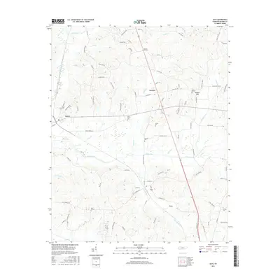
2016 Map of Guys
USGS Topo · Published 2016About this map
Eastview and Gravel Hill sit at the center of this McNairy County landscape, where the terrain is defined by a dense network of tributaries feeding into Muddy Creek. The region’s settlement pattern is closely tied to its waterways and early road networks, such as Ramer Selmer Rd and Gravel Hill Rd. For family historians, the sheet is particularly valuable for its density of rural burial grounds, including Pleasant Grove Cem, Mount Vernon Cem, and Houston Cem. The western edge is marked by the community of Ramer, while Guys anchors the southern portion of the quadrangle. Significant water features like Prairie Br, Roland Cr, and Cypress Creek Ditch illustrate the complex drainage of this West Tennessee pocket. The map provides a clear look at the proximity of local landmarks and family-named roads that often define generational landholdings in the area.
Find a feature on this map
87 named features on this map. Tap any name to fly to it.
Don’t see what you’re looking for? This feature index may not catch every label — zoom into the map to look around manually.
Map Details
Editions of this 2016 Guys Map
This is the sole edition of this map. No revisions or reprints were ever made.
Other maps of this area
1936 · Kendrick
USGS Topo · 1:24,000
1936 · Purdy
USGS Topo · 1:24,000
1936 · Stantonville
USGS Topo · 1:24,000
1936 · Michie
USGS Topo · 1:24,000
1949 · Purdy
USGS Topo · 1:24,000
1949 · Stantonville
USGS Topo · 1:24,000
1949 · Michie
USGS Topo · 1:24,000
1950 · Corinth
USGS Topo · 1:62,500
1950 · Kendrick
USGS Topo · 1:24,000
1951 · Chewalla
USGS Topo · 1:24,000