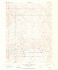
1962 Map of Gypsum
USGS Topo · Published 1964About this map
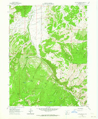
Gypsum serves as the focal point of this 1962 topographic survey, situated where the Denver and Rio Grande Western railroad corridors parallel the Eagle River. The landscape reveals a complex network of agricultural infrastructure, specifically irrigation systems such as the Bartholomew and Chatfield Ditch, Casper Schumm Ditch, and Gates Ditch. These human-made waterways suggest a valley floor dedicated to ranching and farming, contrasting with the high, arid terrain of Greenhorn Mountain and its numerous drainages like Sheep Gulch and Agnew Gulch. North of the river, the settlement of Agnew and a Trailer Park represent the mid-century residential footprint, while the County Airport and a Beacon indicate the area's increasing connectivity. The map also documents local industry through several Gravel Pits and the presence of a Gaging Sta near the town center, monitoring the vital river flow.
Find a feature on this map
32 named features on this map. Tap any name to fly to it.
Don’t see what you’re looking for? This feature index may not catch every label — zoom into the map to look around manually.
Map Details
Editions of this 1962 Gypsum Map
5 editions found
Other maps of this area

1927 · Glenwood Springs
USGS Topo · 1:125,000

1930 · Glenwood Springs
USGS Topo · 1:125,000

1957 · Leadville
USGS Topo · 1:250,000

1959 · Leadville
USGS Topo · 1:250,000

1960 · Leadville
USGS Topo · 1:250,000

1961 · Cottonwood Pass
USGS Topo · 1:24,000

1962 · Leadville
USGS Topo · 1:250,000

1962 · Gypsum
USGS Topo · 1:24,000
1962 · Suicide Mountain
USGS Topo · 1:24,000

1962 · Eagle
USGS Topo · 1:24,000