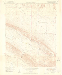
1949 Map of Gypsum Gap
USGS Topo · Published 1949About this map
The Atomic Energy Commission appears prominently on this late 1940s survey of the San Miguel region, reflecting the era's burgeoning interest in radioactive minerals. The landscape is defined by the massive geological corridor of Big Gypsum Valley and the neighboring Disappointment Valley to the south. These troughs are separated by Long Ridge, which served as a focal point for extraction as evidenced by the Long Ridge Mines. The map documents a rugged extractive frontier where numerous small infrastructure improvements—including several Dams, a Ditch, and a Flume—were required to manage water for industrial use. Prospectors and researchers can trace the specific locations of the Bald Eagle Mines and Pitchfork Mines, illustrating the intensity of postwar mineral exploration in this remote corner of Colorado.
Find a feature on this map
13 named features on this map. Tap any name to fly to it.
Don’t see what you’re looking for? This feature index may not catch every label — zoom into the map to look around manually.
Map Details
Editions of this 1949 Gypsum Gap Map
2 editions found
Other maps of this area

1916 · Paradox Valley
USGS Topo · 1:125,000

1922 · Paradox Valley
USGS Topo · 1:125,000

1948 · Bull Canyon
USGS Topo · 1:24,000

1948 · Hamm Canyon
USGS Topo · 1:24,000

1948 · Naturita NW
USGS Topo · 1:24,000

1948 · Gypsum Gap
USGS Topo · 1:24,000

1949 · Bull Canyon
USGS Topo · 1:24,000

1949 · Gypsum Gap
USGS Topo · 1:24,000

1949 · Naturita NW
USGS Topo · 1:24,000

1949 · Joe Davis Hill
USGS Topo · 1:24,000