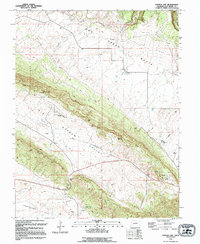
1994 Map of Gypsum Gap
USGS Topo · Published 1994About this map
Dry Creek Basin and the broad expanses of Big Gypsum Valley define this portion of San Miguel County, where the landscape is marked by decades of resource extraction. Numerous mineral workings dot the terrain, including the Bald Eagle Mines, Pritchfork Mines, and an Open Pit Mine located near Long Ridge. The map reveals a network of 4wd tracks and a significant Pipeline cutting through the valleys, supporting the regional energy and mining economy.
Find a feature on this map
25 named features on this map. Tap any name to fly to it.
Don’t see what you’re looking for? This feature index may not catch every label — zoom into the map to look around manually.
Map Details
Editions of this 1994 Gypsum Gap Map
This is the sole edition of this map. No revisions or reprints were ever made.
Other maps of this area

1916 · Paradox Valley
USGS Topo · 1:125,000

1922 · Paradox Valley
USGS Topo · 1:125,000

1948 · Bull Canyon
USGS Topo · 1:24,000

1948 · Hamm Canyon
USGS Topo · 1:24,000

1948 · Naturita NW
USGS Topo · 1:24,000

1948 · Gypsum Gap
USGS Topo · 1:24,000

1949 · Bull Canyon
USGS Topo · 1:24,000

1949 · Gypsum Gap
USGS Topo · 1:24,000

1949 · Naturita NW
USGS Topo · 1:24,000

1949 · Joe Davis Hill
USGS Topo · 1:24,000