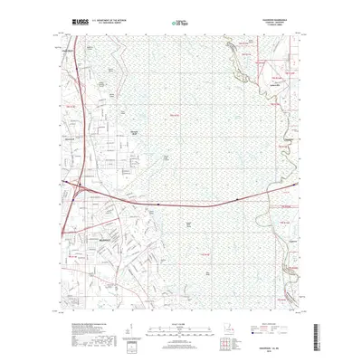
2018 Map of Haaswood
USGS Topo · Published 2018About this map
The West Pearl River and its intricate network of bayous and sloughs dominate this 2018 survey of the borderlands between Louisiana and Mississippi. The landscape is characterized by a massive wetland system, including the Fritchie Marsh and numerous named islands like Porters Island, Whisky Island, and Macks Island. In the southwestern corner, the city of Slidell shows significant suburban expansion, with dense residential street grids reaching toward the marsh edges. Along the eastern bank of the river in Mississippi, historical sites like Logtown and Gainesville reflect the area's river-dependent history. The map is particularly useful for genealogists, as it identifies several small, scattered burial grounds including Napoleon Cem, Gauss Cem, and Rousseaux Cem, providing precise locations for family history research in both St. Tammany Parish and Hancock County.
Find a feature on this map
194 named features on this map. Tap any name to fly to it.
Don’t see what you’re looking for? This feature index may not catch every label — zoom into the map to look around manually.
Map Details
Editions of this 2018 Haaswood Map
This is the sole edition of this map. No revisions or reprints were ever made.
Other maps of this area

1892 · Chef Menteur
USGS Topo · 1:62,500

1893 · Rigolets
USGS Topo · 1:62,500

1914 · Nicholson
USGS Topo · 1:62,500

1921 · Nicholson
USGS Topo · 1:62,500

1935 · Slidell
USGS Topo · 1:62,500

1935 · English Lookout
USGS Topo · 1:31,680

1936 · North Shore
USGS Topo · 1:31,680

1936 · Chef Menteur
USGS Topo · 1:62,500

1936 · Rigolets
USGS Topo · 1:62,500

1939 · Slidell
USGS Topo · 1:62,500