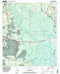
1998 Map of Haaswood
USGS Topo · Published 2000About this map
The West Pearl River and its intricate network of bayous dominate this landscape on the border of Louisiana and Mississippi. The eastern portion of the map is defined by the John C Stennis Space Center (NASA), which sits adjacent to historic settlements like Gainesville and Logtown along the riverbanks. The vast wetlands of the Pearl River State Wildlife Management Area stretch across the center, revealing a labyrinth of waterways including Maddens Slough and English Bayou. In the west, the growing community of Slidell and the smaller Haaswood show the area's residential development during the late twentieth century. Family history is preserved in several rural sites, from the Hartzell Mt Zion Ch to the Rousseaux Cem, while the historic Military Road provides a glimpse into the region's early transportation corridors.
Find a feature on this map
109 named features on this map. Tap any name to fly to it.
Don’t see what you’re looking for? This feature index may not catch every label — zoom into the map to look around manually.
Map Details
Editions of this 1998 Haaswood Map
This is the sole edition of this map. No revisions or reprints were ever made.
Other maps of this area

1892 · Chef Menteur
USGS Topo · 1:62,500

1893 · Rigolets
USGS Topo · 1:62,500

1914 · Nicholson
USGS Topo · 1:62,500

1921 · Nicholson
USGS Topo · 1:62,500

1935 · Slidell
USGS Topo · 1:62,500

1935 · English Lookout
USGS Topo · 1:31,680

1936 · North Shore
USGS Topo · 1:31,680

1936 · Chef Menteur
USGS Topo · 1:62,500

1936 · Rigolets
USGS Topo · 1:62,500

1939 · Slidell
USGS Topo · 1:62,500