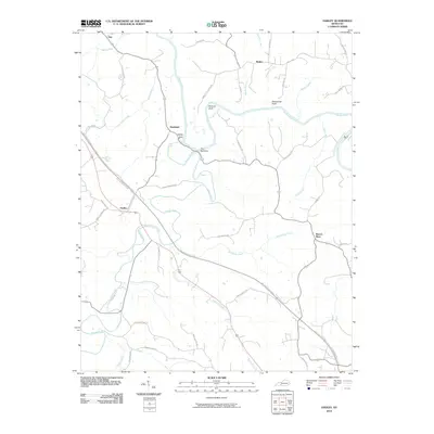
2010 Map of Hadley
USGS Topo · Published 2010About this map
The confluence of the Gasper River and the Barren River defines this portion of Warren County, where the rivers carve a winding path through the Kentucky landscape. Near the center of the sheet, the river makes a tight bend at The Narrows, passing beneath the shadows of Stumps Bluff and the local landmark Sallys Rock. This area is marked by numerous small settlements and rural crossroads, including Hadley, Rockland, and Benleo. The road network reflects a history of family-named lanes and agricultural routes, such as Hammett Hill Rd, Kelly Harris Rd, and Wand Cemetery Rd. To the south, the William Natcher Pkwy cuts across the terrain, contrasting with the older, more organic drainage patterns of Salt Lick Creek and Westbrook Creek. This 2010 survey provides a detailed look at the rural character and topographical features of the region before further modern development.
Find a feature on this map
49 named features on this map. Tap any name to fly to it.
Don’t see what you’re looking for? This feature index may not catch every label — zoom into the map to look around manually.
Map Details
Editions of this 2010 Hadley Map
This is the sole edition of this map. No revisions or reprints were ever made.
Other maps of this area

1914 · Little Muddy
USGS Topo · 1:62,500

1921 · Bowling Green
USGS Topo · 1:62,500

1922 · Brownsville
USGS Topo · 1:62,500

1923 · Bowling Green
USGS Topo · 1:62,500

1923 · Brownsville
USGS Topo · 1:62,500

1951 · South Union
USGS Topo · 1:24,000

1952 · Rockfield
USGS Topo · 1:24,000

1954 · Evansville
USGS Topo · 1:250,000

1954 · Bowling Green North
USGS Topo · 1:24,000
1954 · Reedyville
USGS Topo · 1:24,000