1954 Map of Evansville
USGS Topo · Published 1954About this map
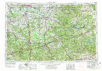
The Ohio River and Green River valleys dominate this mid-century landscape, illustrating the critical water-and-rail network connecting Indiana and Kentucky. Navigational infrastructure is highly visible along the river bends, specifically through US Lock and Dam No 47 and its counterparts, which managed the river's flow for heavy barge traffic. Industrial hubs like Evansville and Owensboro are shown at a time of significant postwar development, while the extensive rail lines of the Louisville and Nashville and Illinois Central systems highlight the region's role as a transit corridor for coal and agriculture. To the south and east, the terrain shifts into the broken uplands of the Coal Knobs and leads toward the subterranean karst geography of Mammoth Cave National Park. Significant military footprints are also evident at Camp Breckinridge Military Reservation and the edge of Fort Knox Military Reservation.
Find a feature on this map
61 named features on this map. Tap any name to fly to it.
Don’t see what you’re looking for? This feature index may not catch every label — zoom into the map to look around manually.
Map Details
Editions of this 1954 Evansville Map
This is the sole edition of this map. No revisions or reprints were ever made.
Historical Maps of Evansville Through Time
6 maps found