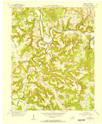
1954 Map of Hadley
USGS Topo · Published 1956About this map
The Barren River and Gasper River wind through the deeply etched hills of Warren County in this mid-1950s study. This rural landscape is defined by its winding waterways and the scattered communities of Hadley, Rockland, and Benleo. The area reveals a quiet but active economy of extraction and faith, with numerous Oil Wells peppered across the eastern ridges and a series of rural sanctuaries like Rolling Spring Ch and Hall Chapel serving the local population.
Find a feature on this map
39 named features on this map. Tap any name to fly to it.
Don’t see what you’re looking for? This feature index may not catch every label — zoom into the map to look around manually.
Map Details
Editions of this 1954 Hadley Map
This is the sole edition of this map. No revisions or reprints were ever made.
Other maps of this area

1914 · Little Muddy
USGS Topo · 1:62,500

1921 · Bowling Green
USGS Topo · 1:62,500

1922 · Brownsville
USGS Topo · 1:62,500

1923 · Bowling Green
USGS Topo · 1:62,500

1923 · Brownsville
USGS Topo · 1:62,500

1951 · South Union
USGS Topo · 1:24,000

1952 · Rockfield
USGS Topo · 1:24,000

1954 · Evansville
USGS Topo · 1:250,000

1954 · Bowling Green North
USGS Topo · 1:24,000
1954 · Reedyville
USGS Topo · 1:24,000