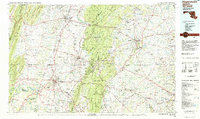
1983 Map of Hagerstown
USGS Topo · Published 1984About this map
The Potomac River and its major tributaries, including Conococheague Creek and Antietam Creek, define the lower valley of this multi-state region during the early 1980s. The landscape is structured by the prominent ridges of South Mountain and Catoctin Mountain, which separate established hubs like Hagerstown, Chambersburg, and Gettysburg. Military and commemorative lands are a significant presence, ranging from the Gettysburg National Military Park and the adjacent Eisenhower National Historic Site to the restricted grounds of the Letterkenny Army Depot and Fort Ritchie Military Reservation.
Find a feature on this map
197 named features on this map. Tap any name to fly to it.
Don’t see what you’re looking for? This feature index may not catch every label — zoom into the map to look around manually.
Map Details
Editions of this 1983 Hagerstown Map
2 editions found
Other maps of this area

1884 · Harpers Ferry
USGS Topo · 1:125,000

1891 · Harpers Ferry
USGS Topo · 1:125,000

1892 · Ellicott
USGS Topo · 1:62,500

1893 · Frederick
USGS Topo · 1:125,000

1893 · Harpers Ferry
USGS Topo · 1:125,000

1894 · Ellicott
USGS Topo · 1:62,500

1894 · Frederick
USGS Topo · 1:125,000

1894 · Winchester
USGS Topo · 1:125,000

1899 · Hancock
USGS Topo · 1:62,500

1900 · Mercersburg
USGS Topo · 1:62,500