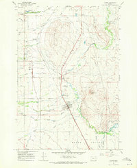
1967 Map of Haines
USGS Topo · Published 1971About this map
The high plains of Baker Valley are defined here by a complex hydraulic landscape where the Powder River and North Powder River meet an intricate network of irrigation ditches and sloughs. In the late 1960s, the community of Haines served as a central hub for this ranching region, situated along the Union Pacific railroad. The geography reveals a transition from the level valley floor to the prominent elevation of Hutchinson Hill and Coyote Point. Local landmarks such as Radium Hot Springs and the Rodeo Grounds south of town suggest a landscape utilized for both thermal resources and community gatherings. For those researching family history, the map includes significant points of interest like the Rock Creek Cem and named waterways including Christensen Slough and Favorite Slough, which likely represent early land-use patterns and family ranching boundaries.
Find a feature on this map
36 named features on this map. Tap any name to fly to it.
Don’t see what you’re looking for? This feature index may not catch every label — zoom into the map to look around manually.
Map Details
Editions of this 1967 Haines Map
This is the sole edition of this map. No revisions or reprints were ever made.
Other maps of this area

1901 · Baker City
USGS Topo · 1:125,000

1901 · Sumpter
USGS Topo · 1:125,000

1906 · Telocaset
USGS Topo · 1:125,000

1953 · Pendleton
USGS Topo · 1:250,000

1955 · Baker
USGS Topo · 1:250,000

1955 · Grangeville
USGS Topo · 1:250,000

1955 · Canyon City
USGS Topo · 1:250,000

1956 · Pendleton
USGS Topo · 1:250,000

1959 · Baker
USGS Topo · 1:250,000

1959 · Grangeville
USGS Topo · 1:250,000