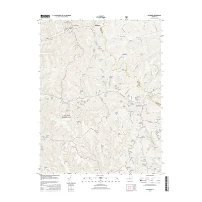
2016 Map of Haldeman
USGS Topo · Published 2016About this map
Elliottville and Haldeman anchor a landscape defined by the deep valleys and ridges of eastern Kentucky, where the Daniel Boone National Forest covers much of the western terrain. This 2016 survey highlights an intricate network of family-named cemeteries and creek branches that tell the story of generations of settlement in Rowan and Carter counties. From Hays Crossing in the northwest to Minor in the southeast, the topography is carved by waterways like Triplett Creek and Christy Creek. A remarkable density of burial sites, such as the Sparks Cemetery One, Richards Cemetery One, and New Sill Cemetery, are tucked into the hollows and along ridgelines like Crix Ridge. These features, along with secondary routes like Fultz Hollow Road and Austin Road, provide a detailed record of the rural communities and family homesteads that persist throughout these hills.
Find a feature on this map
164 named features on this map. Tap any name to fly to it.
Don’t see what you’re looking for? This feature index may not catch every label — zoom into the map to look around manually.
Map Details
Editions of this 2016 Haldeman Map
This is the sole edition of this map. No revisions or reprints were ever made.
Other maps of this area

1929 · Morehead
USGS Topo · 1:48,000

1935 · Morehead
USGS Topo · 1:62,500

1950 · Olive Hill
USGS Topo · 1:24,000

1950 · Ault
USGS Topo · 1:24,000

1950 · Sandy Hook
USGS Topo · 1:24,000

1951 · Soldier
USGS Topo · 1:24,000

1951 · Cranston
USGS Topo · 1:24,000

1953 · Haldeman
USGS Topo · 1:24,000

1953 · Bangor
USGS Topo · 1:24,000
1953 · Wrigley
USGS Topo · 1:24,000