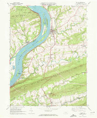
1969 Map of Halifax
USGS Topo · Published 1972About this map
The Susquehanna River dominates this landscape, its waters divided by substantial landforms like Lingle Island, Clemson Island, and Haldeman Island. Along the eastern bank, the town of Halifax serves as a central hub, while smaller hamlets like New Buffalo and Montgomery Ferry mark the historical river crossings and early transport routes of the corridor. The Penn Central tracks hug the shoreline, illustrating the enduring importance of the river valley for transit through the ridge-and-valley province.
Find a feature on this map
60 named features on this map. Tap any name to fly to it.
Don’t see what you’re looking for? This feature index may not catch every label — zoom into the map to look around manually.
Map Details
Editions of this 1969 Halifax Map
2 editions found
Other maps of this area

1892 · Harrisburg
USGS Topo · 1:62,500

1893 · Millersburg
USGS Topo · 1:62,500

1899 · Harrisburg
USGS Topo · 1:62,500

1907 · New Bloomfield
USGS Topo · 1:62,500

1907 · Millerstown
USGS Topo · 1:62,500

1924 · Harrisburg
USGS Topo · 1:62,500

1943 · Millerstown
USGS Topo · 1:62,500

1943 · Millersburg
USGS Topo · 1:62,500

1943 · Harrisburg
USGS Topo · 1:62,500

1943 · New Bloomfield
USGS Topo · 1:62,500