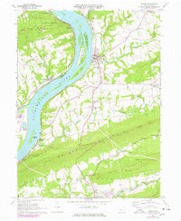
1969 Map of Halifax
USGS Topo · Published 1977About this map
The Susquehanna River dominates this landscape, its wide channel punctuated by substantial islands such as Clemson Island and Bressler Island. Along its banks, the river's influence on settlement and transport is evident in the alignment of the Conrail line and the presence of small riverside communities like New Buffalo and Halifax. To the south, the dramatic ridges of Peters Mountain and Third Mountain create a formidable natural barrier, though the Appalachian Trail follows the spine of the former, offering a pedestrian link through this topographical divide.
Find a feature on this map
65 named features on this map. Tap any name to fly to it.
Don’t see what you’re looking for? This feature index may not catch every label — zoom into the map to look around manually.
Map Details
Editions of this 1969 Halifax Map
2 editions found
Other maps of this area

1892 · Harrisburg
USGS Topo · 1:62,500

1893 · Millersburg
USGS Topo · 1:62,500

1899 · Harrisburg
USGS Topo · 1:62,500

1907 · New Bloomfield
USGS Topo · 1:62,500

1907 · Millerstown
USGS Topo · 1:62,500

1924 · Harrisburg
USGS Topo · 1:62,500

1943 · Millerstown
USGS Topo · 1:62,500

1943 · Millersburg
USGS Topo · 1:62,500

1943 · Harrisburg
USGS Topo · 1:62,500

1943 · New Bloomfield
USGS Topo · 1:62,500