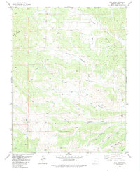
1983 Map of Hall Gulch
USGS Topo · Published 1983About this map
Waugh Mountain and Table Mountain anchor a landscape defined by the drainage networks of the Tallahassee Creek system. This 1983 edition, based on earlier surveys, reveals an area where high-altitude ranching and mining have long coexisted. The central corridor is dominated by Hall Gulch and the Tallahassee School, a vital landmark for the rural community. Industrial activity is evident throughout the eastern half of the map, marked by the Glen Williams Mine, several unnamed Strip Mines, and various Prospect sites.
Find a feature on this map
35 named features on this map. Tap any name to fly to it.
Don’t see what you’re looking for? This feature index may not catch every label — zoom into the map to look around manually.
Map Details
Editions of this 1983 Hall Gulch Map
This is the sole edition of this map. No revisions or reprints were ever made.
Other maps of this area

1889 · Canon City
USGS Topo · 1:125,000

1892 · Canon City
USGS Topo · 1:125,000

1894 · Pikes Peak
USGS Topo · 1:125,000

1901 · Pikes Peak
USGS Topo · 1:125,000

1942 · Cover Mtn.
USGS Topo · 1:62,500

1948 · Cover Mtn.
USGS Topo · 1:62,500

1954 · Pueblo
USGS Topo · 1:250,000

1957 · Pueblo
USGS Topo · 1:250,000

1958 · Pueblo
USGS Topo · 1:250,000

1959 · Black Mountain
USGS Topo · 1:62,500