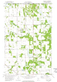
1974 Map of Hallock NE
USGS Topo · Published 1976About this map
The Canada United States border defines the northern edge of this landscape, marked by a Port of Entry U S Customs along the boundary between Manitoba and Minnesota. This agricultural region in Kittson County is characterized by an extensive network of drainage channels, notably State Ditch No 84, which manages the low-lying terrain near the Skull Lake State Wildlife Management Area. The settlement pattern is scattered, with small hubs like the community of Granville and landmarks such as Holy Rosary Ch providing focal points for the rural population.
Find a feature on this map
21 named features on this map. Tap any name to fly to it.
Don’t see what you’re looking for? This feature index may not catch every label — zoom into the map to look around manually.
Map Details
Editions of this 1974 Hallock NE Map
This is the sole edition of this map. No revisions or reprints were ever made.
Other maps of this area

1918 · Hemmington
USGS Topo · 1:62,500

1941 · Hallock
USGS Topo · 1:62,500

1952 · Thief River Falls
USGS Topo · 1:250,000

1956 · Thief River Falls
USGS Topo · 1:250,000

1957 · Thief River Falls
USGS Topo · 1:250,000

1966 · Skull Lake
USGS Topo · 1:24,000
1966 · Skull Lake SW
USGS Topo · 1:24,000

1967 · Thief River Falls
USGS Topo · 1:250,000
1974 · Orleans
USGS Topo · 1:24,000
1974 · Hallock
USGS Topo · 1:24,000