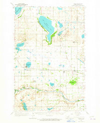
1962 Map of Hamar
USGS Topo · Published 1965About this map
The Sheyenne River winds through the southern reaches of this landscape, its path defined by the Indian Reservation boundary and historical landmarks like the Indian Mound and the Gaging Station. Further north, the expansive waters of East Devils Lake dominate the terrain, reflecting the 1950 mean elevation of 1425 feet. This era shows a settled agricultural grid punctuated by small community hubs such as Warwick and Hamar, where the Great Northern railroad provides a vital link across the prairie.
Find a feature on this map
44 named features on this map. Tap any name to fly to it.
Don’t see what you’re looking for? This feature index may not catch every label — zoom into the map to look around manually.
Map Details
Editions of this 1962 Hamar Map
This is the sole edition of this map. No revisions or reprints were ever made.
Other maps of this area

1928 · Tokio
USGS Topo · 1:62,500

1930 · Pekin
USGS Topo · 1:62,500

1930 · Hamar
USGS Topo · 1:62,500

1931 · Tokio
USGS Topo · 1:62,500

1931 · Devils Lake
USGS Topo · 1:62,500

1944 · Brantford
USGS Topo · 1:62,500

1946 · Brantford
USGS Topo · 1:62,500

1950 · Brantford NE
USGS Topo · 1:24,000

1950 · Tokio
USGS Topo · 1:24,000

1950 · Devils Lake
USGS Topo · 1:62,500