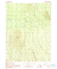
1990 Map of Hambone
USGS Topo · Published 1990About this map
Shasta National Forest dominates this northern California landscape, centered on the logging and transport nexus of Hambone. The map reflects a landscape shaped by industrial forestry and timber management in the late 20th century. Traces of historical logging infrastructure are evident through features like the Old Railroad Grade and the Railroad Grade, indicating how timber was once moved through these hills. Higher elevations are marked by the Bear Lookout atop Bear Mountain and the prominent Hambone Butte. Small settlements and camps like Slagger and the curious Car A (Site) suggest localized activity, while scattered water sources such as White Deer Well, Sand Flat Well, and Mad Well supported operations across the drier upland terrain. The presence of a Cinder Pit and Borrow Pit further points to the maintenance of the forest road network that replaced the rails.
Find a feature on this map
22 named features on this map. Tap any name to fly to it.
Don’t see what you’re looking for? This feature index may not catch every label — zoom into the map to look around manually.
Map Details
Editions of this 1990 Hambone Map
This is the sole edition of this map. No revisions or reprints were ever made.
Other maps of this area

1886 · Modoc Lava Bed
USGS Topo · 1:250,000

1892 · Modoc Lava-Bed
USGS Topo · 1:250,000

1932 · Bartle
USGS Topo · 1:96,000

1939 · Bartle
USGS Topo · 1:125,000

1954 · Alturas
USGS Topo · 1:250,000

1958 · Alturas
USGS Topo · 1:250,000

1961 · Hambone
USGS Topo · 1:62,500

1961 · Pondosa
USGS Topo · 1:62,500
1961 · Big Bend
USGS Topo · 1:62,500

1961 · Bartle
USGS Topo · 1:62,500