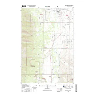
2017 Map of Hamilton South
USGS Topo · Published 2017About this map
The Bitterroot River valley south of Hamilton reveals a landscape defined by the transition from the irrigated valley floor to the steep eastern reaches of the Bitterroot National Forest. In the late 2010s, this area maintains a mix of agricultural legacies and residential clusters at Grantsdale, Ward, and Charlas Heights. The map traces the winding paths of several mountain streams, including Roaring Lion Cr, Gold Cr, and Sleeping Child Cr, as they flow toward the main river channel. Local history and genealogy interests are centered around features like the Grantsdale Cem and the naming of local landmarks such as Tammany Hill and Goat Mtn. The detailed road network, from Grantsdale Cutoff Rd to the various loops serving the foothills, illustrates the continued development of these Ravalli County communities.
Find a feature on this map
81 named features on this map. Tap any name to fly to it.
Don’t see what you’re looking for? This feature index may not catch every label — zoom into the map to look around manually.
Map Details
Editions of this 2017 Hamilton South Map
This is the sole edition of this map. No revisions or reprints were ever made.
Other maps of this area

1901 · Hamilton
USGS Topo · 1:125,000

1956 · Hamilton
USGS Topo · 1:250,000

1959 · Hamilton
USGS Topo · 1:250,000

1960 · Hamilton
USGS Topo · 1:250,000

1964 · Hamilton
USGS Topo · 1:250,000

1964 · Hamilton South
USGS Topo · 1:24,000

1964 · Darby
USGS Topo · 1:24,000

1964 · Ward Mountain
USGS Topo · 1:24,000
1964 · Como Peaks
USGS Topo · 1:24,000
1964 · Deer Mountain
USGS Topo · 1:24,000