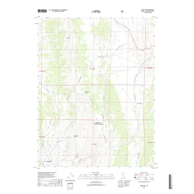
2018 Map of Hamilton
USGS Topo · Published 2018About this map
Hamilton anchors the southwestern corner of this survey, situated at the base of the Mokomoke Mountains and the southern reach of the White Pine Range. The high-altitude landscape is defined by its complex hydrology and a network of traditional routes, including the Belmont Cutoff and the Mokomoke Trail. These paths connect various isolated water sources such as Waterworks Spring and California Spring, which were essential for local life in this arid environment. To the east, Illipah Cr feeds into the Illipah Reservoir, a significant water feature that breaks the dry terrain near Harris Canyon. Within the Humboldt National Forest, the topography rises sharply to summits like Buster Mtn, while deep cuts like Cathedral Canyon reveal the geologic character of the region.
Find a feature on this map
42 named features on this map. Tap any name to fly to it.
Don’t see what you’re looking for? This feature index may not catch every label — zoom into the map to look around manually.
Map Details
Editions of this 2018 Hamilton Map
This is the sole edition of this map. No revisions or reprints were ever made.
Other maps of this area

1949 · Treasure Hill
USGS Topo · 1:62,500

1950 · Treasure Hill
USGS Topo · 1:62,500

1951 · Green Springs
USGS Topo · 1:62,500

1951 · Illipah
USGS Topo · 1:62,500

1951 · Pancake Summit
USGS Topo · 1:62,500

1956 · Ely
USGS Topo · 1:250,000

1959 · Ely
USGS Topo · 1:250,000

1963 · Ely
USGS Topo · 1:250,000

1979 · Mt. Hamilton
USGS Topo · 1:100,000
1990 · Seligman Canyon
USGS Topo · 1:24,000