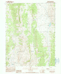
1990 Map of Hamilton
USGS Topo · Published 1990About this map
Hamilton (Historic Ruins) sits at the southwestern edge of this high-altitude landscape, marking a site of significant mining activity in the late 19th century. The terrain is dominated by the north-south ridges of the White Pine Range and the Mokomoke Mountains, where numerous industrial markings like Prospect, Tunnel, and Shaft indicate a landscape heavily worked for mineral wealth. These features are concentrated within the Humboldt National Forest, illustrating the overlap of federal land management and historical resource extraction.
Find a feature on this map
25 named features on this map. Tap any name to fly to it.
Don’t see what you’re looking for? This feature index may not catch every label — zoom into the map to look around manually.
Map Details
Editions of this 1990 Hamilton Map
This is the sole edition of this map. No revisions or reprints were ever made.
Other maps of this area

1949 · Treasure Hill
USGS Topo · 1:62,500

1950 · Treasure Hill
USGS Topo · 1:62,500

1951 · Green Springs
USGS Topo · 1:62,500

1951 · Illipah
USGS Topo · 1:62,500

1951 · Pancake Summit
USGS Topo · 1:62,500

1956 · Ely
USGS Topo · 1:250,000

1959 · Ely
USGS Topo · 1:250,000

1963 · Ely
USGS Topo · 1:250,000

1979 · Mt. Hamilton
USGS Topo · 1:100,000
1990 · Seligman Canyon
USGS Topo · 1:24,000