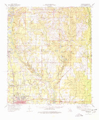
1974 Map of Hammond
USGS Topo · Published 1977About this map
Southeastern Louisiana University and the city of Hammond anchor the southern portion of this mid-1970s survey, illustrating the regional growth along the Illinois Central Gulf railroad. The corridor north toward Amite is dotted with timber-and-truck farming settlements like Natalbany, Tickfaw, and Independence. The landscape is defined by the winding course of the Tangipahoa River, which carves through a terrain of gravel pits and piney woods.
Find a feature on this map
122 named features on this map. Tap any name to fly to it.
Don’t see what you’re looking for? This feature index may not catch every label — zoom into the map to look around manually.
Map Details
Editions of this 1974 Hammond Map
This is the sole edition of this map. No revisions or reprints were ever made.
Other maps of this area

1934 · Springfield
USGS Topo · 1:62,500

1935 · Covington
USGS Topo · 1:62,500

1935 · Ponchatoula
USGS Topo · 1:62,500

1939 · Ponchatoula
USGS Topo · 1:62,500

1939 · Covington
USGS Topo · 1:62,500

1939 · Springfield
USGS Topo · 1:62,500

1940 · Tickfaw
USGS Topo · 1:31,680

1940 · Roseland
USGS Topo · 1:31,680

1942 · Roseland
USGS Topo · 1:31,680

1942 · Onville
USGS Topo · 1:31,680