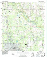
1994 Map of Hammond
USGS Topo · Published 1996About this map
The Tangipahoa River winds prominently through this landscape, defining the character of the region northeast of Hammond during the mid-1990s. The area is marked by a transition from the urbanized sprawl of Southeastern Louisiana University and the Hammond Municipal Airport to the more rural drainage basins of Ponchatoula Creek and Skulls Creek. Numerous family cemeteries, including Mt Stevens Cem, Tycer Cem, and Lanier Cem, are scattered across the terrain, offering significant data points for genealogists tracking local heritage in Tangipahoa Parish. The settlement pattern follows the established corridors of Tickfaw, Natalbany, and Genessee, while land use includes several Gravel Pits and a state Fish Hatchery. This revision reflects the continued development of the parish interior, balancing educational and aviation infrastructure with the preserved rural character of the river's many branches and tributaries.
Find a feature on this map
42 named features on this map. Tap any name to fly to it.
Don’t see what you’re looking for? This feature index may not catch every label — zoom into the map to look around manually.
Map Details
Editions of this 1994 Hammond Map
This is the sole edition of this map. No revisions or reprints were ever made.
Other maps of this area

1934 · Springfield
USGS Topo · 1:62,500

1935 · Ponchatoula
USGS Topo · 1:62,500

1939 · Ponchatoula
USGS Topo · 1:62,500

1939 · Springfield
USGS Topo · 1:62,500

1940 · Tickfaw
USGS Topo · 1:31,680

1942 · Husser
USGS Topo · 1:31,680

1942 · Robert
USGS Topo · 1:31,680

1942 · Loranger
USGS Topo · 1:31,680

1949 · Amite
USGS Topo · 1:31,680

1949 · Albany
USGS Topo · 1:31,680