Loading...
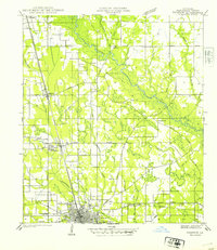
Loading map...1940 Map of Tickfaw
USGS Topo · Published 1940About this map
Hammond and its surrounding parishes appear in 1940 as a hub of rail-dependent activity along the Illinois Central corridor. The town layout is clearly defined, notably featuring the campus of SE La College at its southern edge and the landmark Buell nearby. Moving north, the rail line connects the smaller agricultural and lumber-focused settlements of Natalbany, Tickfaw, and Independence.
Find a feature on this map
33 named features on this map. Tap any name to fly to it.
Don’t see what you’re looking for? This feature index may not catch every label — zoom into the map to look around manually.
Map Details
Date Portrayed1940
Date Published1940
PublisherU.S. Geological Survey
Map TypeTopographic
Scale1:31,680
Physical Dimensions17.9 x 20.7 inches
Editions of this 1940 Tickfaw Map
This is the sole edition of this map. No revisions or reprints were ever made.
Historical Maps of Hammond Through Time
1 maps found
Featured Locations
Source Details
SourceU.S. Geological Survey
CopyrightPublic Domain