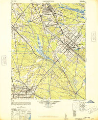
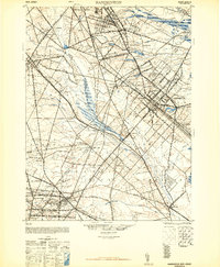
1948 Map of Hammonton
USGS Topo · Published 1948About this map
The Great Egg Harbor River carves a path through this New Jersey Pinelands landscape, serving as a boundary between major townships and fueling a network of smaller streams like Hospitality Branch and Penny Pot Stream. This 1948 military reprint for civil use highlights a region defined by its critical rail infrastructure, where the Reading Lines and Pennsylvania-Reading Seashore Lines intersect at major transit hubs such as Winslow Junction. These rails facilitated the growth of industrial and agricultural centers like Hammonton, which sits at the heart of the sheet near Hammonton Lake. Small, distinct communities including Pestletown, Blue Anchor, and Chesilhurst are connected by arterial routes like the White Horse Pike and Black Horse Pike, illustrating the area's mid-century reliance on both heavy rail and emerging automobile corridors. The terrain is characterized by the Great Swamp Branch and numerous family-named landmarks, reflecting a deep-rooted local history in the counties of Atlantic, Camden, and Gloucester.
Find a feature on this map
97 named features on this map. Tap any name to fly to it.
Don’t see what you’re looking for? This feature index may not catch every label — zoom into the map to look around manually.
Map Details
Editions of this 1948 Hammonton Map
2 editions found
Other maps of this area

1888 · Pemberton
USGS Topo · 1:62,500

1888 · Mount Holly
USGS Topo · 1:62,500

1890 · Great Egg Harbor
USGS Topo · 1:62,500

1890 · Hammonton
USGS Topo · 1:62,500

1890 · Tuckahoe
USGS Topo · 1:62,500

1890 · Bridgeton
USGS Topo · 1:62,500

1890 · Mullica
USGS Topo · 1:62,500

1890 · Glassboro
USGS Topo · 1:62,500

1891 · Philadelphia
USGS Topo · 1:62,500

1893 · Great Egg Harbor
USGS Topo · 1:62,500