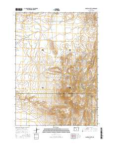
2017 Map of Hampton Butte
USGS Topo · Published 2017About this map
Hampton Butte dominates the southeastern horizon of this high-desert landscape on the boundary of Deschutes and Crook counties. The terrain is defined by a series of intermittent drainages including Hampton Cr, Clover Cr, and Gibson Cr, which illustrate the complex watershed patterns of the Oregon interior. The course of the Dry River cuts through the western portion of the sheet, reflecting an ancient geological path through the sagebrush and juniper country. Human activity is marked by a sparse network of long-distance routes such as Price-Twelvemile Rd and SE Van Lake Rd, which provide access across the wide-open township and range blocks. The presence of features like Yank Gulch and Lizard Cr points to a landscape largely shaped by ranching and traditional land use in a region where water sources are vital landmarks.
Find a feature on this map
20 named features on this map. Tap any name to fly to it.
Don’t see what you’re looking for? This feature index may not catch every label — zoom into the map to look around manually.
Map Details
Editions of this 2017 Hampton Butte Map
This is the sole edition of this map. No revisions or reprints were ever made.
Other maps of this area

1955 · Crescent
USGS Topo · 1:250,000

1957 · Crescent
USGS Topo · 1:250,000

1958 · Crescent
USGS Topo · 1:250,000

1970 · Crescent
USGS Topo · 1:250,000
1983 · Pringle Flat
USGS Topo · 1:24,000

1983 · Hampton Butte
USGS Topo · 1:24,000

1983 · Imperial Valley South
USGS Topo · 1:24,000
1983 · Gerry Mtn
USGS Topo · 1:24,000

1983 · West of Hampton
USGS Topo · 1:24,000
1983 · Imperial Valley North
USGS Topo · 1:24,000