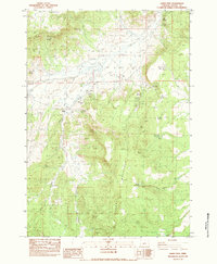
1983 Map of Gerry Mtn
USGS Topo · Published 1983About this map
Gerry Mountain and Sheep Mountain anchor this high-desert landscape in central Oregon, where water management is the primary driver of human activity. The presence of numerous engineered water features like Mule Point Reservoir, Half Way Reservoir, and South Clover Reservoir No 1 suggests a cattle ranching economy dependent on captured seasonal runoff. The isolated Weaver Ranch stands as a primary point of habitation, connected to the wider world by primitive tracks like Pole. Resource extraction is evident through scattered industrial sites including a Rock Quarry and several Open Pit Mines. This 1983 edition captures the land just as it was being managed for grazing and mining, before modern technological shifts altered traditional western range operations. Named springs such as Spanish Spring and Jogi Spring offer clues to the early migration and settlement patterns through these arid Crook County uplands.
Find a feature on this map
30 named features on this map. Tap any name to fly to it.
Don’t see what you’re looking for? This feature index may not catch every label — zoom into the map to look around manually.
Map Details
Editions of this 1983 Gerry Mtn Map
This is the sole edition of this map. No revisions or reprints were ever made.
Other maps of this area

1951 · Post
USGS Topo · 1:62,500

1955 · Crescent
USGS Topo · 1:250,000

1955 · Bend
USGS Topo · 1:250,000

1957 · Crescent
USGS Topo · 1:250,000

1957 · Bend
USGS Topo · 1:250,000

1958 · Crescent
USGS Topo · 1:250,000

1958 · Bend
USGS Topo · 1:250,000

1970 · Crescent
USGS Topo · 1:250,000

1981 · Prineville
USGS Topo · 1:100,000

1982 · Arrowwood Point
USGS Topo · 1:24,000