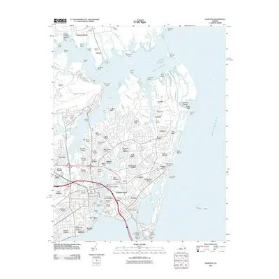
2011 Map of Hampton
USGS Topo · Published 2011About this map
The historical waterfront of Hampton and Poquoson is defined by a complex network of tidal creeks and points extending into the Chesapeake Bay. The maritime and military legacy of the Virginia Peninsula is evident in the presence of Langley Air Force Base and the Old Point Comfort Lighthouse at the southern tip. Local genealogy is well-supported by numerous burial grounds, including the Hampton National Cemetery, Trinity Cemetery, and Oakland Cemetery. The urban landscape shows significant residential density around Phoebus and Buckroe Beach, while older infrastructure like Amorys Wharf and the Grandview Fishing Pier reflect a long-standing reliance on the bay. From the campus of Hampton University to the marshes of Plumtree Island, the map captures the meeting of modern military installations and historic coastal settlements.
Find a feature on this map
126 named features on this map. Tap any name to fly to it.
Don’t see what you’re looking for? This feature index may not catch every label — zoom into the map to look around manually.
Map Details
Editions of this 2011 Hampton Map
This is the sole edition of this map. No revisions or reprints were ever made.
Other maps of this area

1907 · Norfolk
USGS Topo · 1:125,000

1907 · Hampton
USGS Topo · 1:62,500

1918 · Cape Henry
USGS Topo · 1:62,500

1919 · Cape Henry
USGS Topo · 1:62,500

1921 · Newport News
USGS Topo · 1:62,500

1943 · Richmond
USGS Topo · 1:250,000

1944 · Hampton
USGS Topo · 1:24,000

1944 · Messick
USGS Topo · 1:24,000

1944 · Morrison
USGS Topo · 1:24,000

1944 · Harris Grove
USGS Topo · 1:24,000