1944 Map of Morrison
USGS Topo · Published 1944About this map
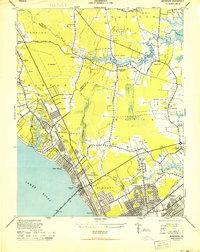
Hilton Village and North Newport News anchor this 1944 military survey, revealing a landscape defined by World War II-era mobilization and historic Tidewater geography. The map shows significant military footprints at Camp Patrick Henry, Camp Morrison, and Camp Hill, alongside established communities like Denbigh and Poquoson. A notable site for historians is the Big Bethel Battlefield, situated near the Big Bethel Reservoir and a landmark known as the Broken Bridge.
Find a feature on this map
75 named features on this map. Tap any name to fly to it.
Don’t see what you’re looking for? This feature index may not catch every label — zoom into the map to look around manually.
Map Details
Editions of this 1944 Morrison Map
This is the sole edition of this map. No revisions or reprints were ever made.
Other maps of this area

1907 · Norfolk
USGS Topo · 1:125,000

1907 · Yorktown
USGS Topo · 1:62,500

1907 · Hampton
USGS Topo · 1:62,500

1919 · Smithfield
USGS Topo · 1:62,500

1921 · Newport News
USGS Topo · 1:62,500

1943 · Yorktown
USGS Topo · 1:62,500

1943 · Richmond
USGS Topo · 1:250,000

1944 · Hampton
USGS Topo · 1:24,000
1944 · Yorktown
USGS Topo · 1:24,000
1944 · Messick
USGS Topo · 1:24,000