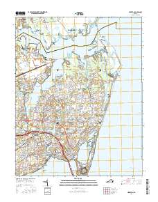
2016 Map of Hampton
USGS Topo · Published 2016About this map
The coastal landscapes of the Virginia Peninsula are shown here in detail, centered on the urban core of Hampton and its surrounding waterfront neighborhoods. The map highlights a complex geography of tidal marshes and points, from Old Point Comfort at the southern tip to Plumtree Island and the Poquoson River in the north. This 2016 survey documents the extensive residential development that has filled in the areas between historical landmarks, including the campus of Hampton Univ and the sprawling Langley Air Force Base.
Find a feature on this map
280 named features on this map. Tap any name to fly to it.
Don’t see what you’re looking for? This feature index may not catch every label — zoom into the map to look around manually.
Map Details
Editions of this 2016 Hampton Map
This is the sole edition of this map. No revisions or reprints were ever made.
Other maps of this area

1907 · Norfolk
USGS Topo · 1:125,000

1907 · Hampton
USGS Topo · 1:62,500

1918 · Cape Henry
USGS Topo · 1:62,500

1919 · Cape Henry
USGS Topo · 1:62,500

1921 · Newport News
USGS Topo · 1:62,500

1943 · Richmond
USGS Topo · 1:250,000

1944 · Hampton
USGS Topo · 1:24,000

1944 · Messick
USGS Topo · 1:24,000

1944 · Morrison
USGS Topo · 1:24,000

1944 · Harris Grove
USGS Topo · 1:24,000