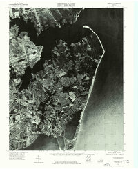
1973 Map of Hampton
USGS Topo · Published 1977About this map
Hampton and its surrounding coastal landscape are captured in high detail through this 1973 orthophotograph, produced under the direction of state geologist James L. Calver. The imagery reveals the intricate relationship between the dense urban grid and the fingers of the Chesapeake coastline, highlighting the developed waterfront and extensive naval or aeronautical infrastructure. This specific survey provides a direct visual record of mid-century suburban expansion and industrial land use before later decades of coastal redevelopment. By combining aerial photography with traditional topographic precision, the map offers a unique perspective on the area's transition into a modern maritime and military hub.
Find a feature on this map
2 named features on this map. Tap any name to fly to it.
Don’t see what you’re looking for? This feature index may not catch every label — zoom into the map to look around manually.
Map Details
Editions of this 1973 Hampton Map
This is the sole edition of this map. No revisions or reprints were ever made.
Other maps of this area

1907 · Norfolk
USGS Topo · 1:125,000

1907 · Hampton
USGS Topo · 1:62,500

1918 · Cape Henry
USGS Topo · 1:62,500

1919 · Cape Henry
USGS Topo · 1:62,500

1921 · Newport News
USGS Topo · 1:62,500

1943 · Richmond
USGS Topo · 1:250,000

1944 · Hampton
USGS Topo · 1:24,000

1944 · Messick
USGS Topo · 1:24,000

1944 · Morrison
USGS Topo · 1:24,000

1944 · Harris Grove
USGS Topo · 1:24,000