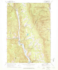
1970 Map of Hancock
USGS Topo · Published 1972About this map
The White River carves a narrow valley through the heart of the Green Mountain National Forest on this 1970s record of central Vermont. Settlement follows the river corridor, where the hamlets of Granville, Lower Granville, Hancock, and Rochester serve as anchors in a landscape defined by the steep rises of Braintree Mountain and the Northfield Mountains. The map reveals a transition in land use, showing traditional infrastructure like the Hancock Tunnel and family-named cemeteries alongside newer recreational markers like Camp Killooleet and Mountain Dairy Campground. Higher elevations remain largely wild, marked by geographical landmarks such as Old Sixty Hill, Thunder Head, and the Lookout Tower near Mt Cushman. Tributaries like Thatcher Brook and Tucker Brook drain the high gaps, illustrating the classic drainage patterns that historically dictated the placement of mountain roads and small-scale Vermont agriculture.
Find a feature on this map
48 named features on this map. Tap any name to fly to it.
Don’t see what you’re looking for? This feature index may not catch every label — zoom into the map to look around manually.
Map Details
Editions of this 1970 Hancock Map
3 editions found
Other maps of this area

1915 · Rochester
USGS Topo · 1:62,500

1917 · Rochester
USGS Topo · 1:62,500

1919 · Royalton
USGS Topo · 1:62,500

1919 · Lincoln Mountain
USGS Topo · 1:62,500

1920 · Lincoln Mountain
USGS Topo · 1:48,000

1921 · Lincoln Mountain
USGS Topo · 1:62,500

1922 · Barre
USGS Topo · 1:48,000

1924 · Barre
USGS Topo · 1:62,500

1924 · Randolph
USGS Topo · 1:48,000

1926 · Randolph
USGS Topo · 1:62,500