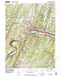
1996 Map of Hancock
USGS Topo · Published 2000About this map
The town of Hancock serves as a critical junction point where the Mason and Dixon Line meets the winding Potomac River, creating a narrow corridor of Maryland between Pennsylvania and West Virginia. This 1996 survey illustrates the layered transportation history of the region, where the Chesapeake and Ohio Canal and its National Historical Park parallel the river through deep mountain gaps. To the south, the West Virginia panhandle features the northern edge of Berkeley Springs and smaller communities like North Berkeley and Jimtown.
Find a feature on this map
51 named features on this map. Tap any name to fly to it.
Don’t see what you’re looking for? This feature index may not catch every label — zoom into the map to look around manually.
Map Details
Editions of this 1996 Hancock Map
This is the sole edition of this map. No revisions or reprints were ever made.
Other maps of this area

1898 · Paw Paw
USGS Topo · 1:62,500

1899 · Hancock
USGS Topo · 1:62,500

1900 · Pawpaw
USGS Topo · 1:62,500

1901 · Hancock
USGS Topo · 1:62,500

1910 · Paw Paw
USGS Topo · 1:62,500

1925 · Needmore
USGS Topo · 1:48,000

1927 · Clearville
USGS Topo · 1:48,000

1931 · Clearville
USGS Topo · 1:62,500

1935 · Needmore
USGS Topo · 1:62,500

1939 · Needmore
USGS Topo · 1:62,500
Featured Places
- Hancock, MD
- Berkeley Springs, Bath (Berkeley Springs)
- Stanley, MD
- Sphors Crossroads, WV
- Bethel Township, PA