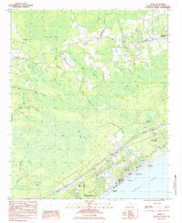
1984 Map of Hand
USGS Topo · Published 1984About this map
The coastal transition of Horry County is clearly marked here by the contrast between inland swamp systems and the burgeoning development of Myrtle Beach. To the north and west, the landscape is defined by an intricate network of wetlands including Jones Big Swamp, Lewis Ocean Bay, and Cane Patch Swamp, interspersed with small rural clusters like Hand and Star Bluff Crossroads. These areas reflect a slower pace of life, anchored by community landmarks such as Sharon Ch and Chesterfield Ch.
Find a feature on this map
46 named features on this map. Tap any name to fly to it.
Don’t see what you’re looking for? This feature index may not catch every label — zoom into the map to look around manually.
Map Details
Editions of this 1984 Hand Map
2 editions found
Other maps of this area

1937 · Myrtle Beach
USGS Topo · 1:48,000

1937 · Nixonville
USGS Topo · 1:48,000

1940 · Myrtle Beach
USGS Topo · 1:62,500

1942 · Nixonville
USGS Topo · 1:62,500

1943 · Wampee
USGS Topo · 1:24,000

1944 · Longs
USGS Topo · 1:31,680

1949 · Georgetown
USGS Topo · 1:250,000

1953 · Longs
USGS Topo · 1:24,000

1967 · Georgetown
USGS Topo · 1:250,000

1974 · Georgetown
USGS Topo · 1:250,000
Featured Places
- Myrtle Beach, SC
- North Myrtle Beach, SC
- Briarcliffe Acres, SC
- Arcadian Shores, SC
- Star Bluff Crossroads, SC