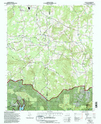
1994 Map of Handy
USGS Topo · Published 1996About this map
The Uwharrie National Forest anchors the southern landscape of this mid-1990s survey, where the Uwharrie River meets the northeastern reaches of Badin Lake. The terrain is defined by a network of rural settlements and agricultural crossroads such as Handy, Complex, and Loflin, interspersed with numerous community anchors like Siloam Ch and New Hope Ch. Notable elevations including Pinson Hill and Chapel Hill rise above the drainage basins of Cabin Creek and Loflin Creek. The map documents a deeply established rural social fabric, evidenced by the high density of country churches and the Salem Ch Cem, alongside later developments like a Golf Course and the Denton Airport Ch. This geography marks the intersection of three counties—Davidson, Randolph, and Montgomery—reflecting a transition from managed forest lands to settled Piedmont hillsides.
Find a feature on this map
69 named features on this map. Tap any name to fly to it.
Don’t see what you’re looking for? This feature index may not catch every label — zoom into the map to look around manually.
Map Details
Editions of this 1994 Handy Map
This is the sole edition of this map. No revisions or reprints were ever made.
Other maps of this area

1942 · Troy
USGS Topo · 1:125,000

1949 · High Rock
USGS Topo · 1:24,000

1949 · Denton NW
USGS Topo · 1:24,000

1953 · Raleigh
USGS Topo · 1:250,000

1953 · Charlotte
USGS Topo · 1:250,000

1954 · Charlotte
USGS Topo · 1:250,000

1954 · Raleigh
USGS Topo · 1:250,000

1957 · Albemarle
USGS Topo · 1:62,500

1957 · Denton
USGS Topo · 1:62,500

1957 · Troy
USGS Topo · 1:62,500