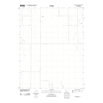
2010 Map of Hanover NW
USGS Topo · Published 2010About this map
Drennan Coal Mine and the small settlement of Crows Roost anchor this high plains landscape in El Paso County during the early 21st century. The terrain is defined by the ephemeral drainages of Chico Creek in the west and Black Squirrel Creek to the east, illustrating the arid hydrology of the region. A strict section-line road grid, including S Peyton Hwy and S Ellicott Hwy, reveals a pattern of dispersed rural development and large-scale land divisions. Modern residential traces appear through uniquely named thoroughfares such as Whistling Hills Ln and Higby Horse Ln, contrasting with the industrial legacy suggested by the nearby coal workings. This survey provides a clear view of the ranching and resource-extraction roots of the area before significant suburban expansion reached this portion of the county.
Find a feature on this map
20 named features on this map. Tap any name to fly to it.
Don’t see what you’re looking for? This feature index may not catch every label — zoom into the map to look around manually.
Map Details
Editions of this 2010 Hanover NW Map
This is the sole edition of this map. No revisions or reprints were ever made.
Other maps of this area

1893 · Big Springs
USGS Topo · 1:125,000

1893 · Colorado Springs
USGS Topo · 1:125,000

1909 · Colorado Springs
USGS Topo · 1:125,000

1942 · Colorado Springs
USGS Topo · 1:125,000

1948 · Fountain SE
USGS Topo · 1:24,000

1948 · Falcon
USGS Topo · 1:62,500

1949 · Corral Bluffs
USGS Topo · 1:24,000
1950 · Fountain NE
USGS Topo · 1:24,000
1950 · Fountain SE
USGS Topo · 1:24,000
1951 · Falcon
USGS Topo · 1:62,500