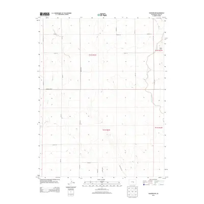
2013 Map of Hanover NW
USGS Topo · Published 2013About this map
Chico Cr and Black Squirrel Cr define the hydrological character of this high plains landscape in El Paso County. The terrain is marked by the distinctive elevation of Crows Roost in the northeast, overlooking a grid of rural access roads that tell the story of modern land division and agricultural reach. Major north-south corridors like S Peyton Hwy and S Ellicott Hwy anchor the transport network, while family-named routes such as Hemmingway Rd, Milne Rd, and Demmler Rd suggest the enduring presence of local ranching or homesteading history. The map captures a transition where the open drainage of the creek beds meets the engineered geometry of residential and agricultural lanes like Whistling Hills Ln and Hobby Horse Ln, reflecting the subtle evolution of the Colorado plains.
Find a feature on this map
24 named features on this map. Tap any name to fly to it.
Don’t see what you’re looking for? This feature index may not catch every label — zoom into the map to look around manually.
Map Details
Editions of this 2013 Hanover NW Map
This is the sole edition of this map. No revisions or reprints were ever made.
Other maps of this area

1893 · Big Springs
USGS Topo · 1:125,000

1893 · Colorado Springs
USGS Topo · 1:125,000

1909 · Colorado Springs
USGS Topo · 1:125,000

1942 · Colorado Springs
USGS Topo · 1:125,000

1948 · Fountain SE
USGS Topo · 1:24,000

1948 · Falcon
USGS Topo · 1:62,500

1949 · Corral Bluffs
USGS Topo · 1:24,000
1950 · Fountain NE
USGS Topo · 1:24,000
1950 · Fountain SE
USGS Topo · 1:24,000
1951 · Falcon
USGS Topo · 1:62,500