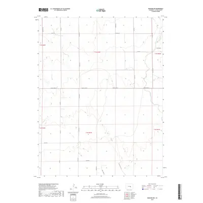
2019 Map of Hanover NW
USGS Topo · Published 2019About this map
Chico Creek and Black Squirrel Creek drain this high plains section of El Paso County, where wide-open ranch lands are partitioned by a grid of named rural roads. The landscape is defined by its drainage patterns and the large-scale township and range sections that organize the territory east of the Front Range. While largely uninhabited by dense settlements, the map identifies Crows Roost in the northeastern quadrant, a localized landmark along S Ellicott Hwy. The transportation network is a mix of primary corridors like S Peyton Hwy and smaller, family or ranch-named routes such as Hemmingway Rd, Bar 10 Rd, and Whistling Hills Ln. This 2019 survey documents the contemporary land use and road development in a region where historical watercourses remain the primary geographic features.
Find a feature on this map
24 named features on this map. Tap any name to fly to it.
Don’t see what you’re looking for? This feature index may not catch every label — zoom into the map to look around manually.
Map Details
Editions of this 2019 Hanover NW Map
This is the sole edition of this map. No revisions or reprints were ever made.
Other maps of this area

1893 · Big Springs
USGS Topo · 1:125,000

1893 · Colorado Springs
USGS Topo · 1:125,000

1909 · Colorado Springs
USGS Topo · 1:125,000

1942 · Colorado Springs
USGS Topo · 1:125,000

1948 · Fountain SE
USGS Topo · 1:24,000

1948 · Falcon
USGS Topo · 1:62,500

1949 · Corral Bluffs
USGS Topo · 1:24,000
1950 · Fountain NE
USGS Topo · 1:24,000
1950 · Fountain SE
USGS Topo · 1:24,000
1951 · Falcon
USGS Topo · 1:62,500