
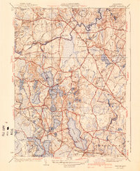
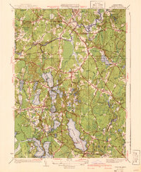
1940 Map of Hanover
USGS Topo · Published 1949About this map
The North River and its many tributaries, including the Indian Head River and Drinkwater River, define this landscape of Plymouth County during the late 1940s. The area is characterized by an intricate network of ponds and swamps, such as Oldham Pond, Furnace Pond, and Pine Island Swamp, which provided the water power for local industry at sites like the Mill Ponds. Settlement patterns center on historic villages like Hanover Center and Pembroke, with the New York New Haven and Hartford railroad line connecting the more remote outposts like Halifax Sta. Local social foundations are well-documented through several educational and religious landmarks, including the Thomas Sch, Bethel Chapel, and the Lady of the Lake Church situated near the Monponsett area. Genealogists will find significant value in the detailed plotting of family-named burial grounds like Magoun Cem and Pine Grove Cem.
Find a feature on this map
116 named features on this map. Tap any name to fly to it.
Don’t see what you’re looking for? This feature index may not catch every label — zoom into the map to look around manually.
Map Details
Editions of this 1940 Hanover Map
3 editions found
Other maps of this area

1885 · Abington
USGS Topo · 1:62,500

1885 · Duxbury
USGS Topo · 1:62,500

1885 · Middleboro
USGS Topo · 1:62,500

1886 · Plymouth
USGS Topo · 1:62,500

1888 · Duxbury
USGS Topo · 1:62,500

1888 · Middleboro
USGS Topo · 1:62,500

1888 · Abington
USGS Topo · 1:62,500

1889 · Plymouth
USGS Topo · 1:62,500

1893 · Abington
USGS Topo · 1:62,500

1893 · Duxbury
USGS Topo · 1:62,500