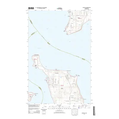
2014 Map of Hansville
USGS Topo · Published 2014About this map
The tip of the Great Peninsula and the southern reaches of Whidbey Island are separated by the deep waters of the Admiralty Inlet and Puget Sound in this 2014 survey. Maritime navigation is a central theme, evidenced by the strategic placement of the Point No Point Light, Double Bluff Light, and Point Hannon Light. On the Kitsap County side, the settlement of Hansville sits near Norwegian Point, while the interior of the peninsula shows a network of residential roads like Hansville Rd NE and NE Gust Halvor Rd. Small inland water bodies such as Buck Lake and Coon Bay break up the landmass, while the northern section across the water features the community of Freeland and the secluded Oliver Lake. Researchers will find local landmarks including Hansville Cem and the Mirth Airport near Foulweather Bluff, documenting the modern layout of these coastal communities.
Find a feature on this map
72 named features on this map. Tap any name to fly to it.
Don’t see what you’re looking for? This feature index may not catch every label — zoom into the map to look around manually.
Map Details
Editions of this 2014 Hansville Map
This is the sole edition of this map. No revisions or reprints were ever made.
Other maps of this area

1895 · Snohomish
USGS Topo · 1:125,000

1897 · Seattle
USGS Topo · 1:125,000

1911 · Mount Vernon
USGS Topo · 1:125,000

1937 · Port Gamble
USGS Topo · 1:62,500

1939 · Coupeville
USGS Topo · 1:62,500

1940 · Port Gamble
USGS Topo · 1:62,500

1942 · Edmonds
USGS Topo · 1:62,500

1943 · Stanwood
USGS Topo · 1:62,500

1953 · Hansville
USGS Topo · 1:24,000

1953 · Freeland
USGS Topo · 1:24,000