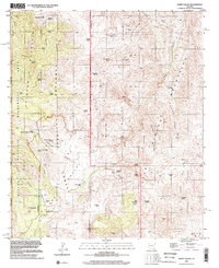
1996 Map of Happy Valley
USGS Topo · Published 2002About this map
The Rincon Mountains and Little Rincon Mountains converge in this high-desert landscape along the border of Pima and Cochise counties. Much of the western terrain is protected within the Saguaro Wilderness Area and Coronado National Forest, where steep canyons like Espiritu Canyon and Sycamore Canyon drain toward the central valley. This area remained largely defined by traditional ranching and remote outposts through the late 20th century, evidenced by the presence of the Last Chance Ranch and Barney Ranch. A complex network of springs, including Dripping Spring and Mesquite Canyon Spring, provided essential water for livestock and wildlife in a region marked by extreme elevation changes. Significant peaks such as Lechuguilla Peak and Driscoll Mtn overlook the winding course of Paige Creek, which serves as a primary geographic corridor through the quadrangle.
Find a feature on this map
63 named features on this map. Tap any name to fly to it.
Don’t see what you’re looking for? This feature index may not catch every label — zoom into the map to look around manually.
Map Details
Editions of this 1996 Happy Valley Map
This is the sole edition of this map. No revisions or reprints were ever made.
Other maps of this area

1904 · Tucson
USGS Topo · 1:125,000

1905 · Tucson
USGS Topo · 1:125,000

1945 · Redington
USGS Topo · 1:62,500

1945 · Happy Valley
USGS Topo · 1:62,500

1956 · Tucson
USGS Topo · 1:250,000

1957 · Bellota Ranch
USGS Topo · 1:62,500

1957 · Rincon Valley
USGS Topo · 1:62,500

1957 · Redington
USGS Topo · 1:62,500

1958 · Tucson
USGS Topo · 1:250,000

1958 · Happy Valley
USGS Topo · 1:62,500