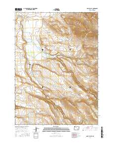
2017 Map of Happy Valley
USGS Topo · Published 2017About this map
Happy Valley is defined by a landscape of volcanic rims and high desert drainages in Harney County, where ranching heritage is inscribed into the geography. The map reveals the local legacy of the Smyth family, marked by the Smyth Cem and the nearby Smyth Reservoir along Smyth Cr. The terrain rises sharply from Fisher Flat toward the prominent heights of Riddle Mtn and Little Riddle Mtn, while Riddle Rim overlooks the eastern part of the quadrangle. High-altitude water sources like Skidoo Spring and Road Lake suggest the seasonal rhythms of the area, further emphasized by the presence of The Lambing Ground on the slopes above Swamp Cr. A small network of routes, including Coon Town Rd and Happy Valley Rd, provides the primary access through this high-country basin and its surrounding hills.
Find a feature on this map
27 named features on this map. Tap any name to fly to it.
Don’t see what you’re looking for? This feature index may not catch every label — zoom into the map to look around manually.
Map Details
Editions of this 2017 Happy Valley Map
This is the sole edition of this map. No revisions or reprints were ever made.
Other maps of this area

1955 · Burns
USGS Topo · 1:250,000

1955 · Adel
USGS Topo · 1:250,000

1957 · Adel
USGS Topo · 1:250,000

1958 · Burns
USGS Topo · 1:250,000

1958 · Adel
USGS Topo · 1:250,000

1959 · Burns
USGS Topo · 1:250,000

1962 · Adel
USGS Topo · 1:250,000

1967 · Happy Valley
USGS Topo · 1:24,000

1967 · Barton Lake
USGS Topo · 1:24,000

1967 · Diamond
USGS Topo · 1:24,000